My wife bought a pontoon this summer and while I’m not an avid angler, it has given us more opportunities to go fishing. If you’re out on the lake, why not drop a line in? 🎣

I’m normally one of those guys that buys the waterproof lake map to keep in the boat:
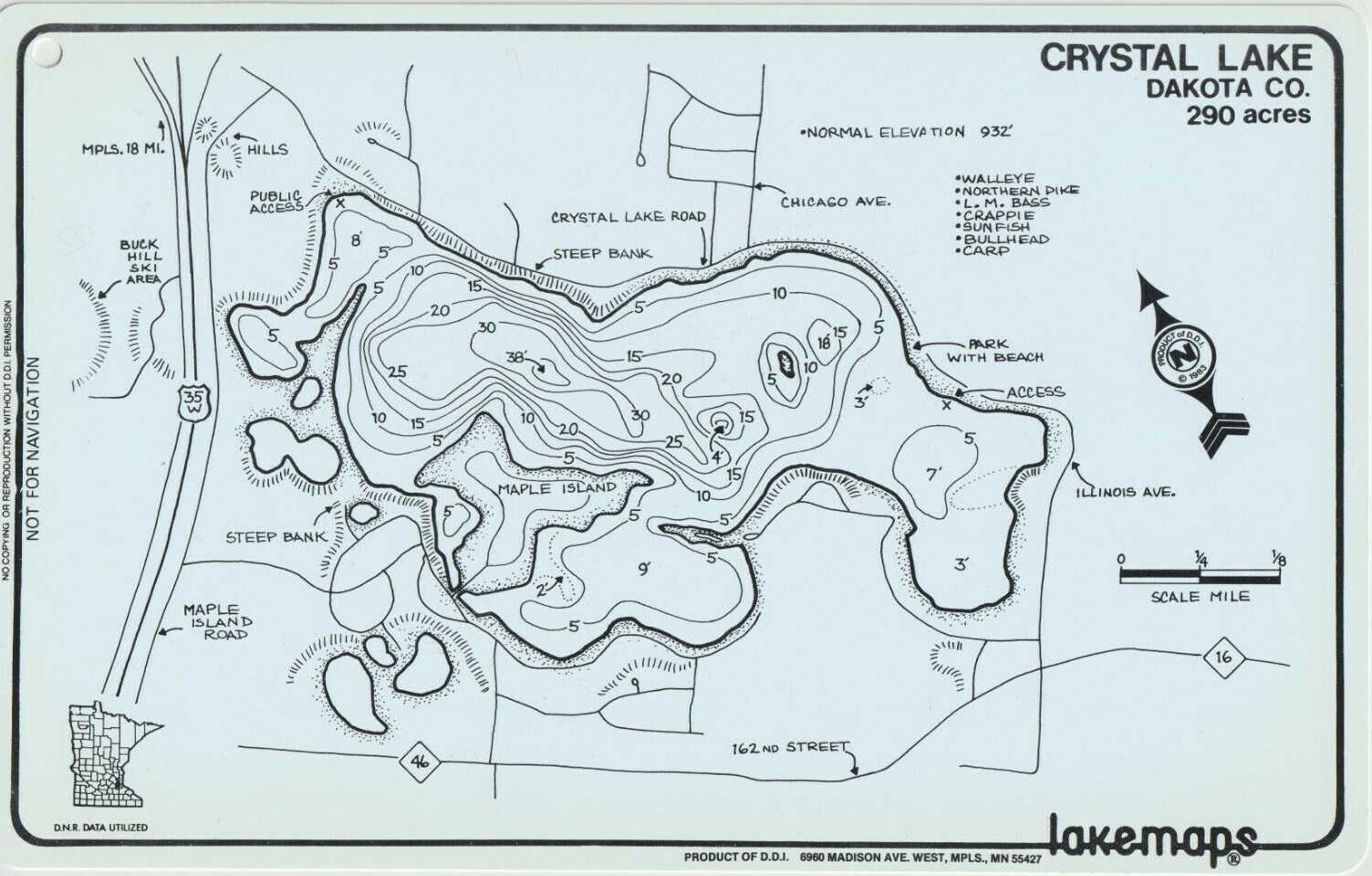
These Minnesota-made lakemaps are no longer produced and considered “vintage” – but you can still get them at bait shops around the state. What about something a little more high tech, but not too expensive? I went to eBay looking for an old multi-mode Garmin GPS and got a nüvi 500 that has modes for driving, hiking, biking and boating.
Knowing that it was pretty easy to load Open Street Maps onto my handheld Garmin eTrex Vista HCx, I assumed I could do the same thing with the nüvi 500… Yes and no. You can do it, but it’s not easy.
Sea vs. Lake
The first thing to understand is commercial and free maps such as Garmin Bluechart and Open Sea Map are for ocean-going. The only lakes they cover are the Great Lakes and some very popular inland waters, such as the Boundary Waters. Loading those maps will allow the nuvi to switch to “Boat Mode” (you must have a nautical map loaded to switch), but they won’t have any info about your local lake. Also, the older Garmin Inland Lakes maps that used to work for this unit is no longer available. Planned obsolescence is an art, not a science 😩
Boat Mode
I found Jeff Jahr’s boatmode.img file which is an empty map with the nautical flag set that allows me to choose “Boating” as the mode. The file needs to be renamed to gmapsupp.img and placed in a garmin folder either on a microSD card (inserted near the battery) or on the device’s internal memory.
But you can really only have one or two gmapsupp.img files on the device (one in internal memory and one on the SD card). How can I add more map data? It turns out these img files act as containers and can contain many maps 💪 Here’s how I put them together
The Process
To put these together I used a Windows computer. All of the software shown here is available for MacOS as well. It is probably possible in Linux, but I don’t (yet) know how to do the GPX to IMG conversion. If you have Linux tips, share them in the comments.
Download Lake Contours
I get the lake depth contours from the MN DNR “Lake Finder” – just search for the lake you frequent and click the “Google Earth / KML” link in the sidebar.
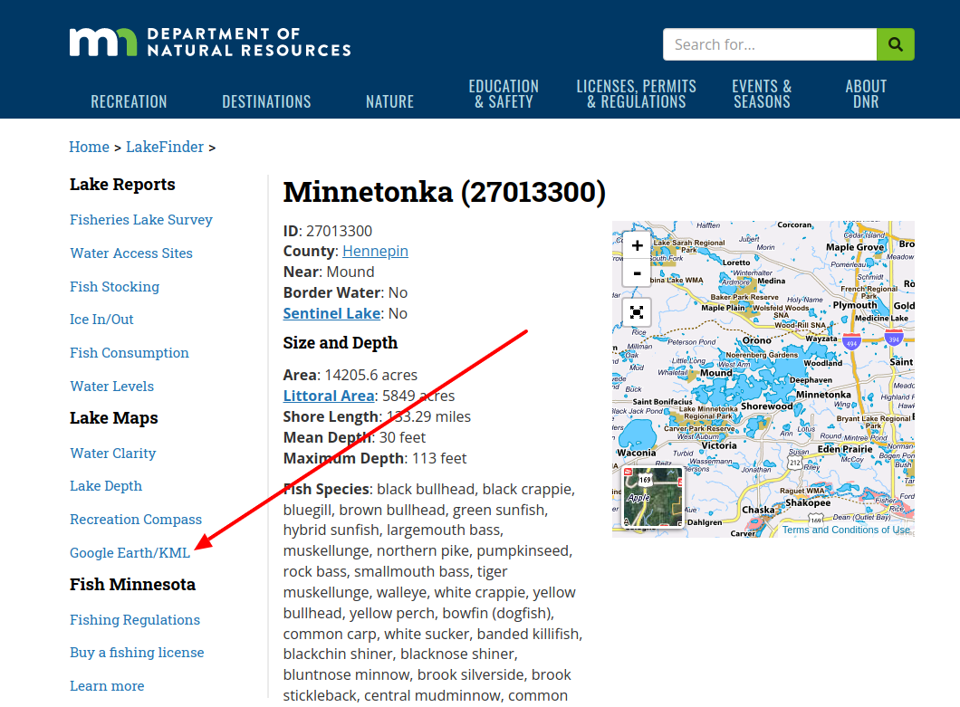
That will download a lake.kml file. I always rename them to lake-name.kml (lake-minnetonka.kml in this case) and put them in a folder with the lake name, because we’ll be repeating this process and adding more files later.
Convert KML to GPX
Use Garmin’s free BaseCamp program to import the KML data into “My Collection.” With BaseCamp installed and started, drag and drop the lake kml file into the “My Collection” folder in BaseCamp.
I like to use BaseCamp because it keeps the contour depth labels when converting to GPX. The downside is it wants to copy those GPX files to your GPS device, so you need to have your GPS plugged in during the conversion.
Select your imported KML lake under “My Collection”, right-click and select “Send To…”
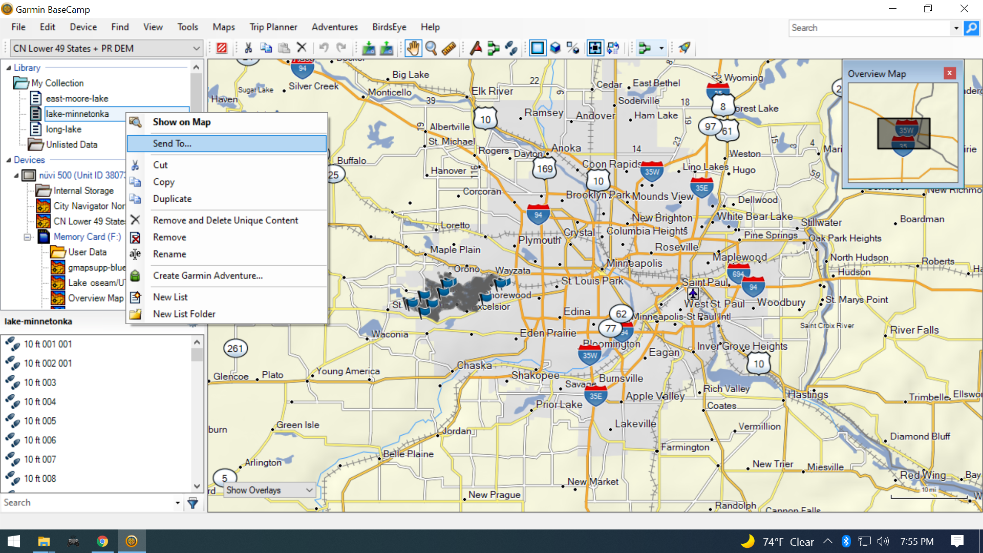
Choose your GPS’s memory card “User Data” folder and the conversion will start. There will be a progress bar under “User Data” while it’s working.
All of the lake depth GPX files will be on your GPS’s memory card in the Garmin -> GPX folder. I move those files back into the lake folder I created earlier for my KML file.
Alternative:
gpsbabel is a cross platform (Windows/MacOS/Linux) program to convert the KML files to GPX, but I couldn’t figure out how to retain the track labels (5ft, 10ft, 15ft, etc.) during conversion. If you know how, let me know in the comments!
Create IMG from GPX
I installed IMGfromGPX (Windows & MacOS only) to turn the lake contour tracks into a map. With IMGfromGPX started, drag the GPX files created by BaseCamp from your lake folder into the main IMGfromGPX window:
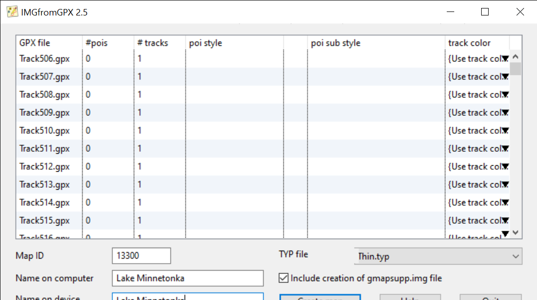
I set the Map ID to the last 4 or 5 digits of the Lake ID on the MN DNR site – just in case they need to be unique. Set the computer/device names to the lake name – that name is what shows up in the “Map Info” screen on your Garmin. For TYP file select “Thin.typ” to keep the contour lines thin. I don’t mess with track color since the default has been fine.
Check “Include creation of gmapsupp.img file” and then push the “Create map” button. It will prompt where to save your data – choose your lake folder. Ignore any prompts to run registry files – we’re not using these maps with MapSource or other mapping software on the computer.
Linux Only:
I think that mkgmap can turn GPX files into a Garmin IMG file. If you know how to do it, let me know in the comments.
Combine multiple IMG files
Repeat these steps for whatever lakes you frequent:
- Download Lake Contours
- Convert KML to GPX
- Create IMG from GPX
Once you’ve got a few, we’ll combine them into one IMG file map using mkgmap. To install mkgmap, I unzipped the mkgmap folder in C:\Program Files\mkgmap-r4807. If you installed yours in a different place, your command for combining them will look a little different – just replace C:\Program Files\mkgmap-r4807\mkgmap.jar with the path to where you installed it.
Since my individual lake folders were all in my Documents\Garmin\Lake KML folder, my command to combine them looked like this:
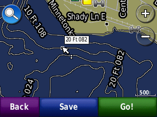
D:\Users\jrfoe\Documents\Garmin\Lake KML>java -jar "C:\Program Files\mkgmap-r4807\mkgmap.jar" --gmapsupp nuvi500boatmode.img bass-lake\gmapsupp.img lake-george\gmapsupp.img lake-minnetonka\gmapsupp.img long-pike-lake\gmapsupp.img moore-lake\gmapsupp.imgOnce they’re combined, you can copy the master gmapsupp.img file to the garmin folder on your microSD card, or directly to the garmin folder on your GPS’s internal memory. When you restart it, you should now have contour lines on the lakes you added:
Conclusion
Yes this process is a bit tedious, but it might give life to an old device that would otherwise get tossed out. I’m not sure if I’ll stick with this unit or not. It’s got some other quirks too – I immediately noticed the clock was wrong as part of some bizarro Y2K for GPSes problem that happened in April 2019.
If I try something different, I’ll probably get a Navionics subscription next summer @ $15/year and use my phone. But if I do ditch this GPS, hopefully this information will be useful for the next owner ♻️
Leave a Reply