When:Saturday June 6th, 2015 – Departing around 2:15PM, other activities before (see below) Where:Islands of Peace Park, Fridley, MN Route: 7.5 miles – Mississippi River Trailer down to Reidel Farm, then over to Main St. and up to Banfill-Locke Center for the Arts – Route Map
After very mild first and second bike tours, Fridley is starting to get behind the bike tour idea… It’s at least on the official Fridley website calendar this year 😎
At 1PM, the Mayor will give a national trails proclamation. Then the community band will be playing an hour long concert. The bike tour is set to depart around 2:15PM, after the band concert.
This will be a family friendly, leisurely ride. I’ll probably have at least one kid in-tow, so feel free to bring your kids along!
We’ll head south on the Mississippi River Trail towards Reidel Farm. I’m hoping to brush up on my history before the ride in case anyone asks about the farm’s significance. Then we’ll cross over the Northtown Yard via the 44th Ave. bridge. We’ll cross into Columbia Heights briefly on the other side of the bridge before getting back into Fridley proper via Main St.
We’ll continue north on the Mississippi River Trail to Locke Lake. We’ll make a short stop at Banfill-Locke Center for the Arts. Then we’ll head back south to Islands of Peace.
Update
After shaking hands with the Mayor during the National Trails Day Proclamation, we listened to the Fridley City Band play some “water music.” One tune was an 80s medley which I believe contained the Police Academy march. I certainly had the tune my head the rest of the day, so I thought I’d share this earworm:
After the concert, it turned out that it would be just myself, a city employee and commissioner on the bike tour. I had contemplated choosing a more friendly and scenic route (having ridden my original route 2 days before). But now was my chance to show city staffers the good, the bad, and the ugly.
The Mississippi River Trail (MRT) for the most part is good.
The bad 44th Ave. bridge was revisited. This time we crossed paths with a pedestrian going the other way on the bridge. He had to stand on top of the jersey barrier while I walked my bike (with trailer) past him because the space is so narrow.
Then we went back north on the ugly part of Main St. It is supposed to have a bike lane the whole length of it, but Anoka County wouldn’t have anything of it. So instead we’re left with the “World’s Shortest Bike Lane” – 4 blocks from 57th to 61st. The part of Main St. that is not a county road. 🙁
Hopefully we can get some of these things remedied by next year!
In 2014 I had a personalban on Strava. Not because Strava has prompted some people to do stupid things (it has), but because they shut down a perfectly working API and left all of their users (and 3rd party developers such as myself) hanging while they developed their “Version 3” API.
I did enjoy using Strava not so much for the competitive-ness, but as a general recording keeping spot for all of my miles. While I understand that competition is the main selling point, it’s ancillary to me. I just like that I can see what my cycling friends are also doing.
Garmin Connect?
In the wake of the API shutdown, I perused the other options out there. Since I had a Garmin GPS, I thought I’d check out their prospects to see if they “get it.” They supposedly had an API for Garmin Connect so I inquired with this email:
I was looking for details about the Garmin Connect Web Services API. All it says is “coming soon” and the developer forum seems to be unmoderated spam:https://forums.garmin.com/forumdisplay.php?54-Garmin-Developer-Information I am an author of the Strava plugin for WordPress – as you may know Strava recently changed it’s API access so many apps and plugins no longer function. Now is the time for disruption! Publishing the Garmin Connect API would be a great way to get some momentum behind the project and get users who are fed up with Strava to come over to Garmin Connect.
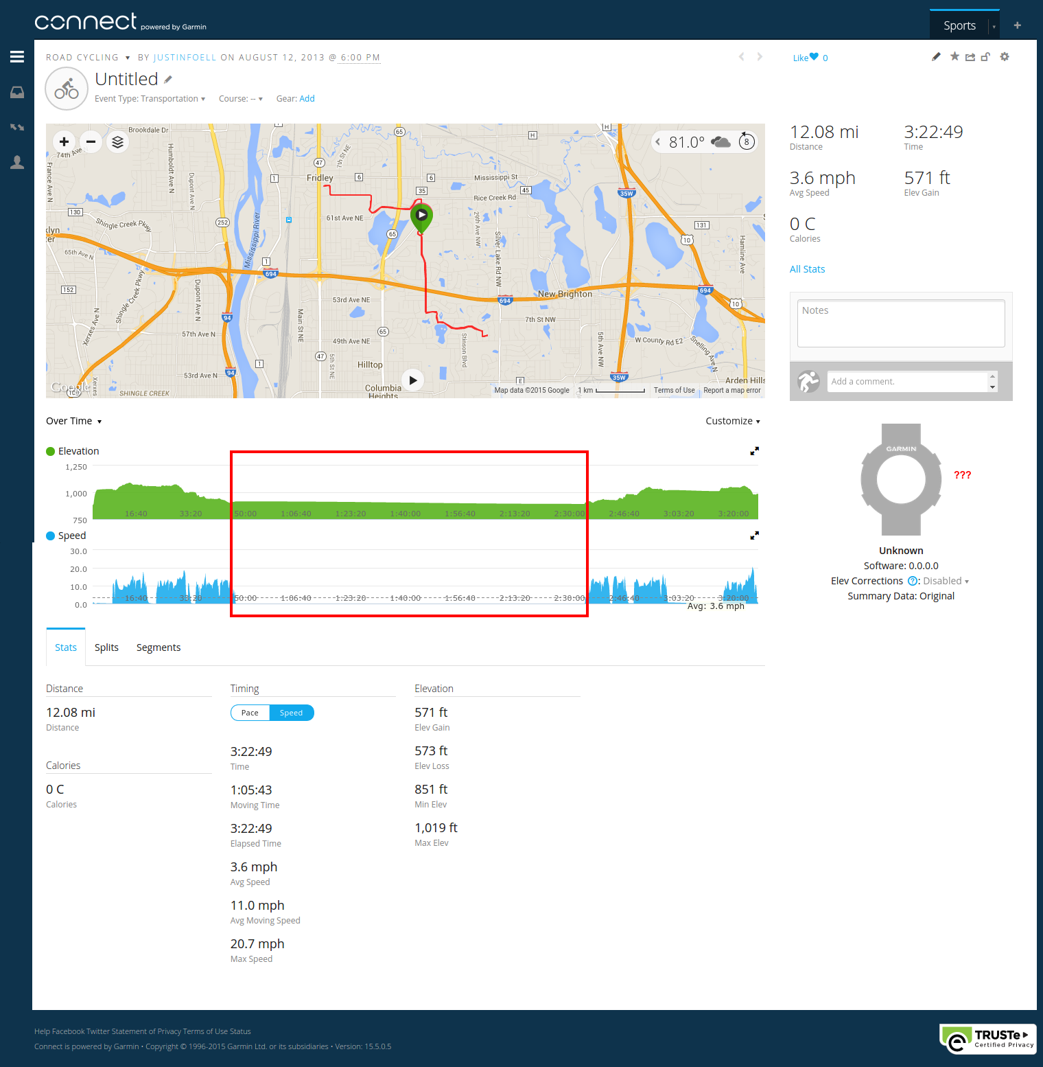
In the meanwhile, I tried out Garmin Connect by uploading a track. One of the niceties about Strava (besides the fact that people are actually using it) is that they remove the non-moving time. Whether I’m at a stoplight or grabbing lunch, I can view a ride as just the moving portion. Garmin awkwardly leaves it in, which can dishearten you when you look at the average speed:
Also, they seem to be heavily invested in relying on Garmin devices (see the watch icon near the question marks above) – and only the latest ones. Lastly, Strava can calculate the calories burned based on my weight and my bike’s weight (part of my profile), measured against the speed and profile of the GPS track.
* Side-note: the latest Garmin Connect dashboard menu looks a lot like the latest WordPress Admin menu, dontcha think?
Garmin Connect – Dead on Arrival
After the less-than-stellar first-time user experience, I heard back from Garmin Support:
After looking in to this issue further it appears that the Web Services API is not yet available. Unfortunately I do not have any information on when the API will become available. Unfortunately the only thing I can suggest is to create a post on the forum asking for more information. I apologize for any inconvenience this may cause.
In the forum, I also got a response from another user who put it bluntly:
Many are those who have contacted Garmin and have not responded.
That project is dead.
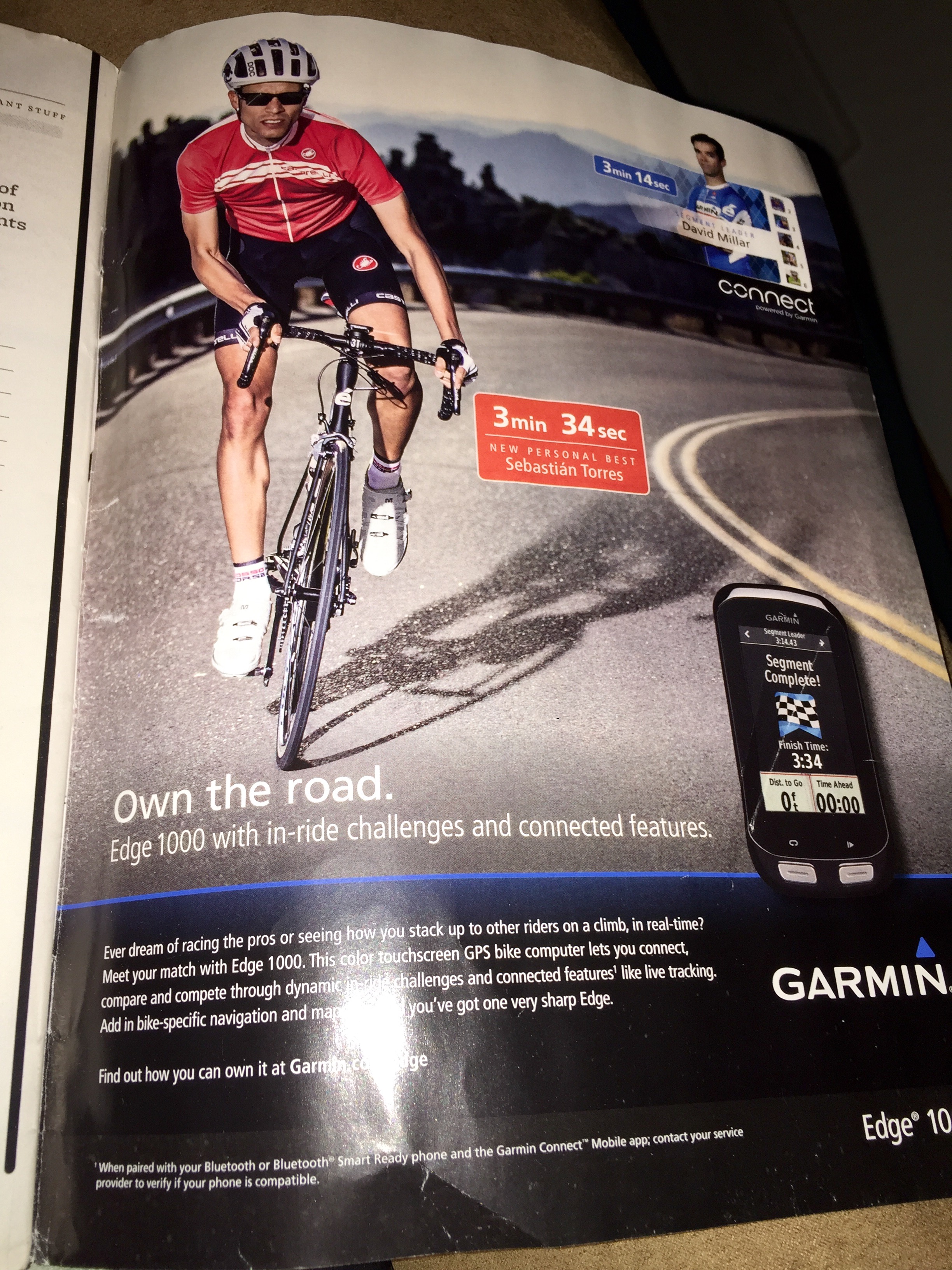
Strangely, Garmin is still pushing their connect service hard, along with their hardware of course:
Garmin Ad in May 2015 Bicycling
The Return of the Strava API
Once the V3 API became available, support tickets regarding WP-Strava started coming in. I didn’t even know that the API had gone public. If there was some sort of communication effort on Strava’s behalf, they failed because I missed it. But now work has slowly come back to life with the WP-Strava project. And now I’m slowly filling in all my rides from 2014 that I recorded with my GPS, but never uploaded to Strava.
MapSource out, QLandkarte In
I used to use MapSource (an old unsupported Windows program by Garmin) to capture my GPS tracks and save them as GPX files for Strava. The state of support for my Garmin Vista HCx was changing in Linux itself. The old garmin_gps driver which acted as an old school serial (COM) port worked with Wine/MapSource, but not with the newer direct USB driver. It was time to find something new, preferably native to Ubuntu.
QLandkarte GT is a somewhat clunky, but usable solution. Actually, when you go to the QLandkarte GT website there’s an announcement about a successor program called QMapShack, but the latest version included in Ubuntu 15.04 wasn’t very full featured – so it will have to wait. I’ve learned to use QLandkarte quickly despite its clunkiness, so I thought I’d share my workflow.
Saving Tracks in QLandkarte GT
I won’t cover downloading tracks from the Garmin, as it was all very easy. Just remember to install the qlandkartegt-garmin package in Ubuntu to get Garmin support in QLandkarte GT.
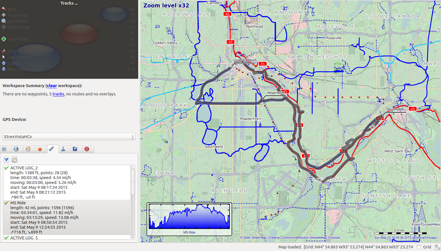
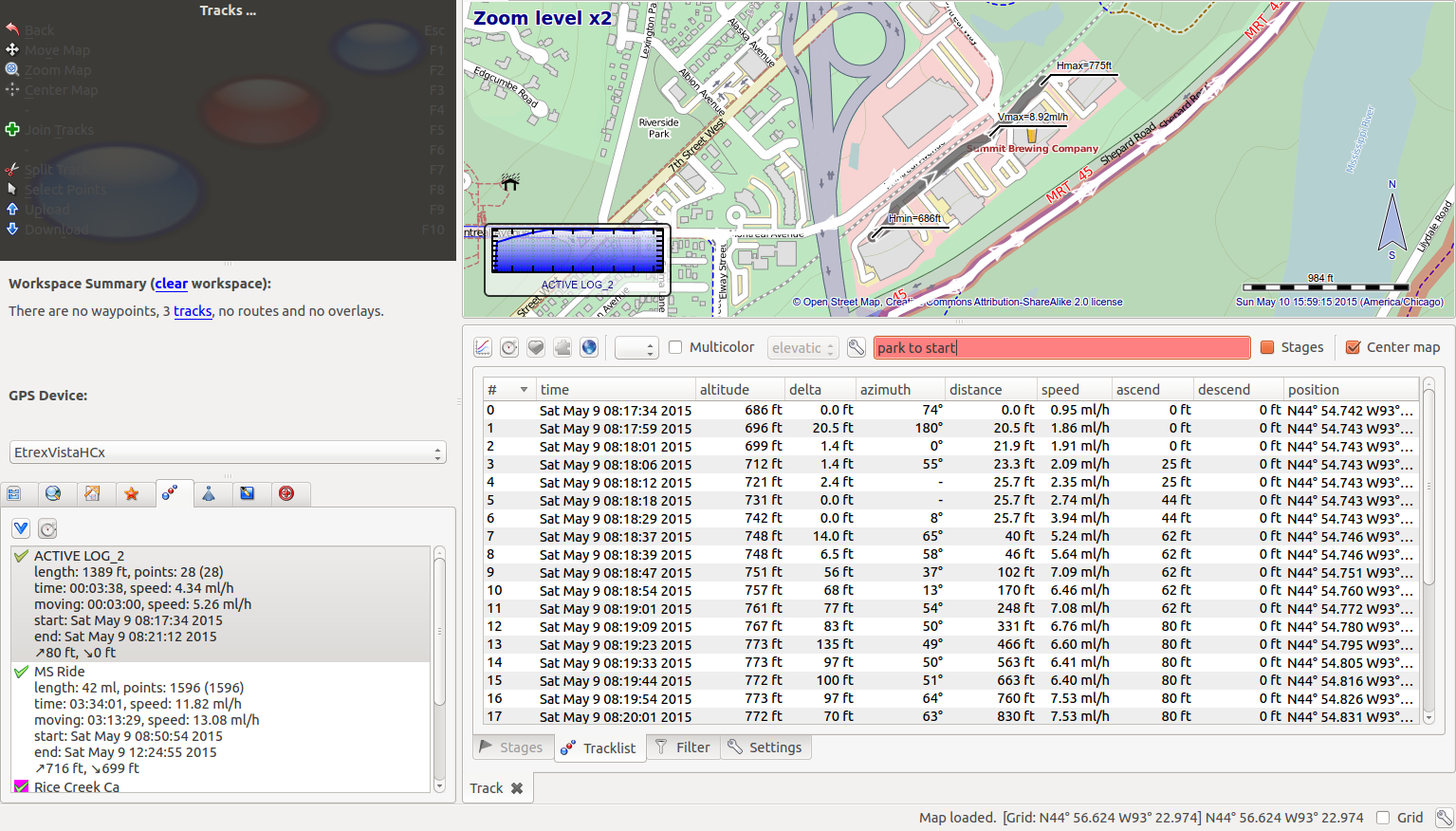
As you can see QLandkarte GT’s color scheme doesn’t exactly jive with Ubuntu’s default color scheme. In the upper left there’s a persistent context menu which may be useful, but the only thing that’s really visible are the icons. The only ones I use regularly are from the Tracks section of the application: the “Join” action (green plus icon) and the “Download” action (blue down arrow icon).
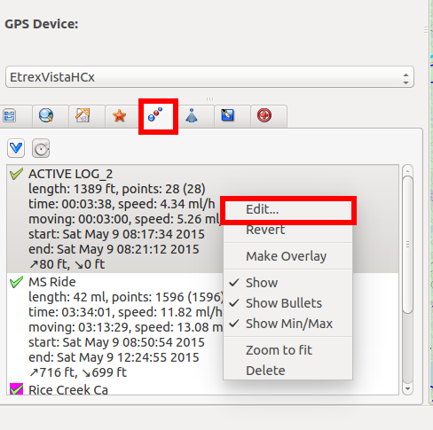
Switch to the tracks tab and then download tracks from the GPS. Then you can edit individual tracks by right clicking and choosing “Edit…”:
Once the track edit screen is open you can change the name of the track, and remove (hide) any points from your track that may be erroneous:
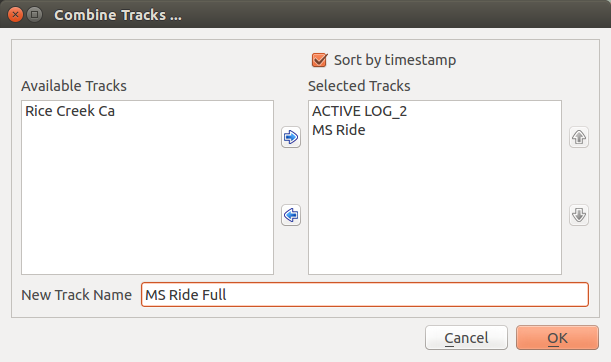
Typically I also need to join tracks, especially if I turned off the GPS at a stop or if the GPS lost signal at any point. Joining tracks is also clunky. You don’t select the tracks and then choose “Join Tracks”, you choose “Join Tracks” which brings up a dialog where you can specify which tracks you want to join, and what new track to save them as:
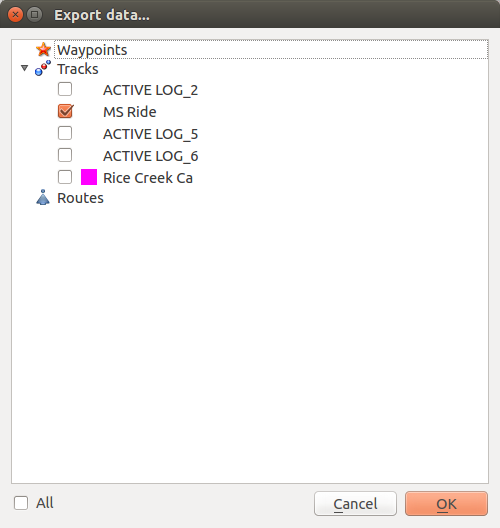
Now that I’ve got my track organized, I want to save it as a GPX file. This took me a while to find, but you need to select File -> Export Geo Data. Then after you select a filename, you’re prompted to select what GPS elements you want to save:
Use the “All” checkbox at the bottom left to un-check all elements, and then you can select just the track(s) you want to export.
Then I can upload them to Strava using their easy-to-find file uploader. Here’s how it looks in a post using WP-Strava:
As a kid I was never really interested in flying models. I could only imagine my first crash with an expensive balsa wood airplane, and the ensuing rebuild.
From then until now two things have taken off (literally):
Jessi got me a GoPro for Christmas a year or so back. I think it was one of those “what do you get for the guy that has everything?” moments. It was quite a surprise and I asked myself what I would use it for at that moment. So I thought I’d reflect on what I have used it for, and what I have yet to use it for.
Jessi got me the entry level “White” GoPro 3. Anything more than this would have been overkill for me. Wi-Fi? Check. 1080p? Check. Even as one of the least expensive models, the GoPro model quickly became clear to me: you’ll almost spend as much on accessories as you did on the camera. Continue reading →
Accessories: where did all my money go?
Here’s a list of all the things I’ve added to my camera:
$80 Wi-Fi remote
$20 HDMI Cable
$20 Mic Cable
$40 “Frame” case & Lens
$20 Extra sticky mounts
That’s $180 alone in accessories. It reminds me of an old bicycle poem found in Grant Peterson’s Just Ride (Ch. 5 – Accessories):
Hey, diddle, diddle,
The bicycle riddle-
The strangest part of the deal.
Just keep your accounts
And add the amounts
The “sundries” cost more than the wheel.
I haven’t purchased the LCD screen “BacPac” – that would definitely put the cost of the accessories over that of the camera. Instead I use the Wi-Fi and the GoPro app on my phone to preview the picture.
After debating between an extra set of mounts and a head-strap, I went with the extra mounts. To substitute for the head-strap, I made a GoPro hat:
I affixed a curved mount to the brim of a baseball cap. The mounts have some pretty awesome 3M double-stick tape. I stuck it onto a black hat I got for free at the Minnesota State Fair. Boom, instant head mount.
Minor Problems, RMA-ed
I’ve used the GoPro to record drum corps rehearsals (with an external mic for better audio). That’s how I found out my camera induced noise into the audio stream when using an external mic with Wi-Fi on.
My camera also had a problem where it would lock up when I connected it via HDMI to my TV. The support team at GoPro couldn’t help me on that, but when I returned my camera to fix the Wi-Fi/audio issue, the HDMI lock-up problem mysteriously went away as well. I suspect there are a few hundred early revisions of the GoPro 3 White hardware floating around out there with these same issues.
I’ve used it as a point and shoot camera in a pinch, although the fish-eye effect needs to be removed:
I strapped it onto an ATV at our Family Reunion:
I used the “GoPro Hat” to document my R/C racing exploits:
I even put a camera in Jules’ R/C car once just for fun:
I also put the camera on my dad’s Lionel train set after getting it up and running. I forgot how much sparks that thing makes (fun)!
Sometime I’m going to put a GoPro on my sport kite, but I worry it would be too dizzying:
I’ll eventually put it in an R/C plane or a multi-rotor copter and try some first person view (FPV) flying, but I need to learn to fly first 🙂 Until then, I’ll just use it whenever the mood strikes.